![]()
K2 Base camp &
Gondogoro La pass
Incredible Baltoro, one of the most beautiful treks in the world, this royal way is leading at the foot of the giants’ planet. Outside polar areas, it is one of the biggest glaciers and its shape is disproportionately sculpted.
From Paju tower, in passing by the exceptional Uli Biaho, and without forgetting the famous Trango towers, everything here is only pure verticals. Kilometres of granite walls rise up above any reason. Come after in this dance, the 7000 peaks, Masherbrum, Muztagh Tower up to Angel Peak, that seems to cuddle shyly close by the gigantesque K2. In Concordia, surrounded by 8000 and 7000 peaks, the show reaches its climax.
K2 base camp will bring you in the Alpinism atmosphere, from the legends engraved in its slopes, up to the failures and deaths buried in this pyramidal coffin wrapped in angelic finery.
For those who continue towards Gondogoro La, a unique panorama in the world, 4 peaks higher than 8000 meters, in a pocket handkerchief. It is followed by a dangerous descent, towards Xhuspang and the Gondogoro Valley, surrounded by steep peaks such as impressive Leila.
An extra walk is possible up to K7 Base Camp with its big walls, steep and virgin cliffs for most of them, the cherry on the cake for very good walkers.
The way that leads to the foot of the “gods’ throne” is unique by its dimensions, and for the trek aficionados, it is a visit no to miss!
DIFFICULTY
Most of the walkers only come in Pakistan for this trek; everything is organized so that they are well acclimatized. Nevertheless, going from the sea level to 5000 m in a week can easily provoke altitude sickness.
Concerning Gondogoro La, the part that goes down towards Xhuspang is extremely steep, ropes are fixed, and you can observe all the equipment horrors: rope worn out, severe friction, 5 persons going down in the same time, etc…
ORGANIZATION
Here, there is a snag… The Baltoro, it’s expensive, even terribly expensive! Those who have a big budget can drop this paragraph; travel agencies organize this itinerary in very good conditions.
For other people who think about organizing it from Pakistan, it is possible but it can take some time, two possibilities:
For the purist trekkers who absolutely chose to do everything by their own means, two or three things to know:
- You need compulsorily to take a licensed guide, and dated the length of the way, you have to hire a cook because the guide will not cook, etc …
- All the team coming with you has to be insured, you have to take care of it.
- In case of a problem related to an accident, and in need of repatriation, you will have had to leave a 5000 USD deposit, to see with your embassy for the intervention of a helicopter, and the insurance liability, see the help rubric.
- You have to possess a permit, because the area is restricted. (See in Islamabad: 50 USD).
- Get cash ready to pay the crossing of different bridges, as well as the use of ropes and a necessary member of the Gondogoro La rescue team.
- Think about the tips budget, see later.
- Ask in Skardu to the guide you will have chosen, for the team shopping, the cook, etc….
- Above all, take your time.
From Thungol, whether it is return trip or up to Hushe, count 19 stages per porter. The salary varies between 180 to 220 rps, organizing it by yourself you might not have the possibility to negotiate prices and the number of stages at the same rate as an agency. The guide will start at 1200 rps per day at least.
Another possibility consists in cutting the pear in two. Organize you permit in Islamabad, and then take your time to join a group in Skardu. Expect between 1 week and 1 month waiting.
We chose that option: after looking for information in all the internet “groups”, we figured that it was worth going through an agency and start organizing it 6 months in advance. After mailing and receiving answers from Pakistanis agencies, the range of prices was between 790 and 4000 per person. What is left to do, is ending the organization in Pakistan, and a little bargaining because prices always end flying up.
Porters will be indemnified which is supposed to be necessary for their way back, the “wasari” (it can be included by certain agencies, inform yourself). In the end, you will have to spend between 120 and 200 USD per person, depending on the group you’re taking part of. As a rule, agencies don’t think it is useful to mention it, and hold on to the calling price.
Tips end up more like a Baksheesh concerning the jeeps, drivers asking as well for it.
WARNING:
It seems that Pakistanis agencies only have one type of offer. Departures from Islamabad, Baltoro, return Islamabad. Get out oft this context and bargain prices is possible if, like us, you go to Skardu by your own means. Mention it in your emails, and negotiate in consequence between you pay, especially if you don’t stay in one of the big hotels.
It is compulsory to pay a deposit by bank transfer to book. You transfer an amount of 200 USD, from bank to bank, pay at first 30 euros for the transfer, and then you find out that 30 USD have been taken on your amount at arrival: total cost of the transfer between 50 and 60 euros! If possible, ask before. We chose to pay the balance in cash to the agency manager without any problem.
This trek needing compulsorily a guide, the itinerary description is succinct.
BEST PERIOD AND SHOPPING
Period
It is better to organize this trek from the end of June to the end of July, after the remains of the monsoon might spoil your spirit and the view. Some groups wait for 3 or 4 days without being able to see the shade of K2. At the end of August, it is not possible to cross Gondogoro La Pass any more.
Shopping
If you organize it by your own means, choose Skardu to buy your food.
MAP
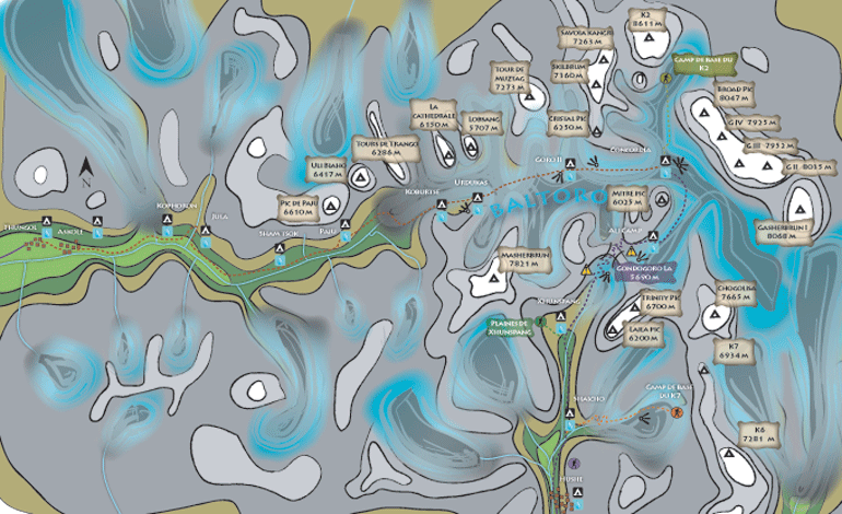
ROUTE
Day 1
Departure: 2850 m
Arrival: 3000 m
Distance: 13 km
Length: 4 to 6 hours
Thungol, is a departure base, follow the way that leads to Askhole, it is necessary to stop and register there at the check post. Then, continue to go up the valley in the middle of the fields, and at the bottom of scree slopes, the way is very weel marked. A few kilometers further, you cross the river coming from the Biafo Glacier, there is a fee for the bridge (As a rule, it is taken in charge by your guide). A great flat area ends up next to the Biafo, at Kophoron, in a willow oasis where tourism impact can be felt.
Day 2
Departure: 3000 m
Arrival: 3300 m
Distance: 16 km
Length: 5 to 8 hours
From Kophoron, the trail goes clearly up the valley. After having followed an affluent, and crossed a bridge, that is 1h30 walking, you reach Jula. Inescapable, the development of this site has set many grey cabins, showers toilets etc…useful but contrasting with the site. After an enjoyable break for eating, because the following part is long, take a path that comes back to the main valley, it goes up to the bottom, and then turns progressively on the left. One hour later and you can see Sham Tsok.
Day 3
Departure: 3300 m
Arrival: 3500 m
Distance: 7 km
Length: 2 to 4 hours
This stage contrasts with that of the day before, from Sham Tsok, go up the valley during half an hour, than go above a gigantic landslide coming from an affluent on your left. Two ways are possible, one on top of this chaos, the other beneath, be careful to the river crossing, late in the day it could be dangerous.
A bit further, go up on the right along the mountain, the trails goes a bit down along the river, and goes up after to arrive in a woody area, you are in Paju. From this camp, the immensity starts to unveil and you can see some part of the Baltoro, the Cathedral, the Trango towers, etc…
Day 4
Rest
Day 5
Departure: 3500 m
Arrival: 4050 m
Distance: 17 km
Length: 6 to 9 hours
This long stage will bring you to the heart of the Baltoro. You leave Paiju on a well marked trail and after half an hour, you see the immensity of the glacier. Go up on the blocks, and cross on the right, you will notice the size of the river that comes out beneath.
One hour crossing, close to a big block, you will see the famous Nameless Tower. Continue on this side, and little by little very vertical peaks unveil, Paiju Peak, Biaho, etc…Go over a sandy area, ideal for pictures, and after 1h30 walking, reach Khoburtse (3900m).Pleasant to stop and have a meal, this windy place is not as nice to sleep.
Go back on track for two hours more and reach Urdukas. Better located than the one before, this camp offers a wonderful panorama on most of the lower Baltoro peaks. Going further where the next stage starts, at the level of porters’ graves, you will have a view on Muztagh Tower and Broad Peak.
Day 6
Departure: 4050 m
Arrival: 4400 m
Distance: 12 km
Length: 5 to 7 hours
The trail takes immediately the glacier’s direction, where you end up after a short descent. The following part is punctuated by a few cairns. One hour later, Masherbrun unveils its splendor, and the peaks you have seen the day before almost seem ridiculous. The itinerary is only on the Baltoro up to Goro II. Be aware that starting from this camp, it becomes very cold; bring a good mattress to isolate yourself from the frozen ground.
Day 7
Departure: 4400 m
Arrival: 4650 m
Distance: 9 km
Length: 4 to 6 hours
Go up along the glacier, one hour later, you have an exceptional panorama on the Muztagh tower that is on your left. Broad Peak and Gasherbrun IV appear at the bottom of the valley. At the junction between upper Baltoro and Godwin Austen Glacier is Concordia camp, the view is breathtaking. The impressing K2 pyramid overlooks the surrounding peaks at 360 °.
Day 8
Rest or day walk to Broad peak or K2 base camp.
RETURN: Take the reverse way, following the itinerary described above.
GONDOGORO LA
Day 9
Departure: 4400 m
Arrival: 4650 m
Distance: 9 km
Length: 4 to 6 hours
From Concordia, a path punctuated of cairns goes up upper Baltoro. One hour later walking, you will see Vigne glacier, arriving from your right, take this direction. The large icy makes you gain altitude progressively until you arrive in a more broken up zone from where you get out and reach Ali camp.
Day 10
Departure: 5000 m
Arrival: 4850 m
Distance: 9 km
Length: 6 to 10 hours
You get up from 11pm for the first groups.
Go up 1 hour in blocks to reach a new camp that you might have reached the day before. A member of the rescue team will come with you during this ascension. Cross the glacier and walk up a slope getting steeper and steeper. Quickly, you will reach the ropes level, they are fixed up to the pass. According to the morphology of this place, changing year after year, you will certainly cross some crevasses covered with ladders.
Arriving at Gondogorola Pass, the landscape is incredible, in front of you, 4 peaks higher than 8000 m in a pocket handkerchief, behind a spectacular valley where Leila Peak thrones. If you reach the pass too early at night, you can wait below for the sunrise in the rescue team hut.
The descent is exhausting; 400 m of difference in height on ropes that are in a terrible shape…the following part is on scree slope, up to a glacier that you will cross. Starting from there, the slope is softer, the walk easier, 1h30 later you will reach Xhuspang.
Day 11
Departure: 4850 m
Arrival: 3300 m
Distance: 18 km
Length: 7 to 10 hours
A long stage that goes gently down to Shaïcho. From Xhuspang, follow the trail which quickly crosses Gondogoro glacier, perpendicular to Leila Peak. The next part, quite easy, offers a great panorama on Masherbrun, and unveils at the bend of the path the gorgeous valley. To tone it down a bit, a river crossing after Golong. Don’t cross it too late, in the afternoon ice melting rises dramatically its water level.
After a few hours walking, you reach a cypress forest, laying its cards on the table for what comes next. Saïcho camp is nested at the bottom of the valley in a bosky bower, contrasting with the mineral world you are leaving.
Day 12
Departure: 3300 m
Arrival: 3000 m
Distance: 8 km
Length: 4 to 6 hours
Take the trail that quickly crosses the river coming from K6 valley. The continuation is easy, descending on a soft slope, in the middle of woody areas. Close to Hushe, the area is cultivated and some inhabitants used to the tourists will not miss asking you some rupees or pens. From Hushe, the view on Masherbrun is awesome.
EXTRAS
K2 Base Camp & Broad Peak
Departure: 4650 m
Arrival: 5100 m
Distance return: 20 km
Length: 8 to 12 hours
Cross Godwin glacier, after 3 hours, you are passing by Broad Peak base camp. Go on, K2 takes all the view, go up along a slope, you arrive at the memorial. Come back the same way.
Xhuspang plains
Departure: 4850 m
Arrival: 5000 m
Distance return: 4 km
Length: 2 to 3 hours
From Xhuspang camp, at the confluence of two rivers, go up the secondary affluent up to grassy plains, free of cattle, flowers are numerous and the atmosphere is pleasant. Easy walk.
K6 Base Camp
Departure: 3300 m
Arrival: 4600 m
Distance return: 27 km
Length: 12 to 14 hours
Especially for very good walkers, it is possible from Saïcho to do this trek up to K6 base camp. Take an extra day and bring a guide with you. The first part is dangerous at times, under big rocks threatening to collapse. The arrival on the Chogolisa glacier is dangerous, the following part not obvious. The vertical walls surrounding you will help you forget about the difficulties. K6 base camp panorama is spectacular.
For those who would like to take more time for this trek, prepare before?
WARNING Treks described in this rubric have all been walked by the author, itineraries are detailed daily, maps and pictures illustrate them. On no account these sheets will replace the experience of a local guide ; they are complementary and should be taken as such! Never go alone, without warning anybody! The course of some trails might change from one year to another, landslides, mud slides are numerous enough. |