![]()
Biafo Hispar |
Its beauty competes with that of Baltoro, even if it is much less visited. Probably the hardest trek in the world, close to 130 km of glacier; 7 icy strips crossed back and forth! Unique landscape of the Snow Lake, the biggest glacier basin outside the polar area, 1500 m of ice.
An exhausting technical trek, crevasses scattered all over, walking in rope teams necessary during a few days…All along the walk, 7000 peaks, again and again, a dozen, including terrible Kunyang Chish or Destagil Sar slopes.
A complete trek, you might be able to link from Hushe with the Gondogoro La crossing, 250 km, for one of the most fascinating walks on earth.
DIFFICULTY
It is the hardest in Pakistan… Get ready for mountaineering conditions, snow, cold, huge changes of temperature. Water quality is quite bad all along the way. There is only Bitanmal camp where it is clear enough.
Watch out for crevasses, from Baintha to Kani Basa, they are many. You will see your porters step over them to save time. It is not very smart; we tried to explain them but nothing to do. Be aware that they are a few dying at this stupid game.
My first crevasse.
We were going up to the pass, avoiding crevasses. All tied with ropes, the guide first and me just behind. He must have been a bit lighter, because as he was 3 metres ahead when the snow bridge he had just crossed collapsed under my weight. I shouldn’t have eaten too many biscuits early in the morning. Deep in the snow up to my shoulders, I ended up swimming at more than 5000 m to get out. Of course we were tied with ropes; therefore I came out easily of this trap. How happy I was not to feel my feet hanging over emptiness. The porters put their weight down and passed their load over the hole. Afterwards, we caught a glimpse at this dark blue abyss, impossible to see the bottom…
At the end of the summer, a German guy told us that one of his porters lost his load on Hispar in a similar situation. The problem is that he had the food. They ended eating wild onions to finish the trek.
ORGANIZATION
Different possibilities
Whether an agency from abroad: As a rule, no too many surprises.
Or a Pakistani agency.
We have been offered (best rate) 65 USD/person/day. In the end, it can be more interesting to organize your trek this way.
Of course you have to check everything offered by the agency, if it is all included or if there are extra fees, it is a specialty in Pakistan.
You organize it by yourself, and it is a marathon ; here is what you have to do (take 2 to 3 days):
First of all, find a guide knowing the trek. The best remains Skardu (see Hispar= problem?). In many hotels of the town, they will introduce you to guides.
Talk about the itinerary, sometimes it can be that the way changes, that camps become difficult to reach, etc…
Guide between 1000 and 1200 rps/day. Tips between 2500 and 4000 rps.
Then, hire a team.
If you take a cook, 500 rps/day. Tips, half as much as the guide.
Porters, it is better to hire them in Skardu. See with the guide, they always know people. We paid 7500 rps/ porter for the whole way: Askole-Nagyr. Add 1000 rps for the tips which also includes the wapasi and of course if everything went well, a goat in Hispar (3000 to 4000 rps). Don’t underestimate this bonus; it is important to the eyes of your team, a boost!
Make sure they have proper gear for carrying weight as well as waterproof drums.
Our team was 1 guide, 1 cook and 7 porters.
You have to be insured. Of you will have thought of getting insurance for this type of activities. Helicopter rescue, death, etc…
More than other treks, you have to insure your team. It is a bit cynical, but a member of your team will only be compensated if he dies. The price of a man’s life is 1000€/porter and 2000 €/guide. Let your team know they are insured, it will be very positive.
To insure them, it is an obstacle course!
There is only one company insuring this type of activities in Pakistan.
ALFA Insurance
Office suite N°18, 2nd floor
Hillview plaza, 76-E Sinnag Avenue
Blue area
Islamabad
Tel : 2274032
Fax : 2274034
Dealing directly with them can be to pull out one’s hair. Go through an agency, they are used to organize this type of provision. Ask your guide.
Include at least 3000 rps to insure ALL your team. You will be sent a certificate, as well as a list to fill out with these details: team members’ names, their birthdates, and identity card number. Send it back when all your team is definitive and BEFORE LEAVING for Askole.
Go to Skardu DC office (police). To go up to Askole, you need their permission. Otherwise, no way you can go through Check Posts. You will have a chance to have a tea with Skardu Deputy Commissioner! Take photocopies of your passports.
Shopping:
For: Olivier & Pascale, 1 guide, 1 cook, 7 porters.
14 jours : Askole – Nagyr.
Around : 12000 rps
Sugar
5 kg
Powdered milk
4 kg
Rice
20 kg
Flower
40 kg
Cooking oil
6 kg
Dahl (lentils)
8kg
Potatoes
8 kg
Eggs
20
Masala
1 pack
Salt
1.6 kg
1 vinegar bottle
1
1 ketchup bottle
1
Pasta
1 kg
Happy cow (laughing cow)
3 packs
Soup
9 packs
Biscuits
20 packs
Toilet paper
6 packs
Lighters
3
Peach powdered drink
1
Coffee
1 pack
Honey
1
Jam
2 kg
Blue plastic sheet
1
Stove
1
Pharmacy
1
Fuel tank for stove
30 kg
Gas
8 kg
Rent material :
1 kitchen tent : 4200 rps
1 kitchen utensils complete set, saucepan, knives…. 4200 rps
1 rope (10m/pers) : 700 rps
1 ice axe : bought 1200 rps
Make 1 first aid kit for the team.
Disinfectant, a few bandages, band aids, eye drops, paracetamol with and without codeine. Antibiotics: amoxiline. Water purification tablets.
Flagyl : Dysentery
Imodium : diarrhoea
It has been a bit tight. Our cook who was taking care of the stock, and helped us out with the shopping, wasn’t really well organized and when it was time to cook, he did as he liked! 40kg of flour, it is a bit too much according to other cooks, and we didn’t have enough! At the end of the shopping day, we didn’t buy that much and we already have too much weight. Of course, we didn’t want to eat only rice and chapattis all along the way…so we managed to take a minimum anyway.
Organize a jeep up to Askole Get 5000 rps ready for a special where you will put all your team. Of course, if you arrive in Askole, be aware that you are lucky. The road is blocked very often. Try to get the information before and negotiate your price according to it.
One last thing to avoid a strike. During the Biafo Hispar crossing, it happens that porters from some teams go on strike. Not surprising, it is hard and they would like to get a bit more. To anticipate, I included a 1000 rps wapasi, and I promised a goat if everything went fine. We didn’t have this type of problem.
Go to Askole, cross the Check Posts. Leave the day after.
Hispar = problems?
It is for sure that Biafo – Hispar itinerary is easier this way than the other way around. Hipar Biafo is harder for the porters, it is less regular and they are more loaded.
Actually, we heard about the difficulties that can happen with Hispar people. When, in Hunza, we have been offered to go with a team from this valley, we thought why not? We will be able to figure out if this reputation is right.
Les premiers jours ça a été a peu près, ils nous ont juste laissé en plan 2 fois sur le glacier. Pascale was a little bit slower, I was waiting for her, and our guide was ahead without worrying too much about us… I am as well a spelunking and canyoneering federal guide, as a rule, I don’t act this way. Anyway, the 2nd time it happened, I thought it was a good thing to let him know because he seemed not to know that a guide remains with his group. It solved the problem. But it would have been the same with any guide.
It is in Hispar that everything started. In fact, we negotiated to go up to Nagyr, and paid for it.
When we arrived in their village, coming out straight from the Middle Age, we thought for a moment that we were in a remake of « The Name of the Rose ». But it was worse, women were avoiding us when we were getting closer, or the ones daring a bit more were turning their back to us. Our team had wished to be paid in their village, and of course someone would be available to go down to Nagyr with us for no extra money!
Of course we didn’t need all the team to go there. They offered us as well to meet the jeep driver who could bring us down the day after…Ok, we accepted, it is only human…and we paid them.
The day after, we were meeting the driver, and it all started to go wrong; 5000 rps (65 €) for 30 km, it is a bit too much. Therefore, we offered them what was decided the day before, to go with someone since we had paid up to Nagyr (of course I would have given a tip on top of it, it’s normal…) and they told us it was 2 stages, 600 rps per stage.
We were going mad! We left walking up to Nagyr, whereas they were laughing their ass off.
Too bad for them, I think that the reputation of Hispar village is for a reason, it is the same for Nagyr (They are conscious of it and they make some efforts).
It is too bad the inhabitants of this valley take the tourist systematically for a milking cow. Anyway, it is our experience and we wanted to share it. If we had to do it again, we would go with Skardu Baltits.
BEST PERIOD AND RESUPPLYING
Mid July – End of August
Skardu : see organization
MAP
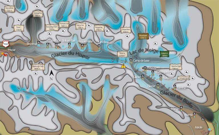
This itinerary doesn’t take into account rest days; it is possible to take on in Baintha for acclimatization or after Hispar La.
Day 1
Askole – Namla
Departure: 3000 m
Arrival: 3350 m
-335 m + 675 m
Distance: 15 km
Length: 7 to 8 hours
Get out Askole going up the valley. The track under construction is well marked, and walked by many groups going to Baltoro on the right. After 2 km, a climb up to the summit where you can see the valley and the terminal part of Biafo, go down et leave the Baltoro bridge on the right. Far on the left hand side, a small pass, this where you have to go. After 1 hour, it is from this place you have the first view on the glacier, landslides hills surrounded by black ice. The trail follows the border of the lateral moraine; before reaching a cliff, go down on the glacier, it’s steep. Continue along the Biafo’s limit one good hour until a camp where it is possible to eat. The trail continues until it is blocked by crevasses, 300 to 400 m before, get on the glacier and walk around the chaotic part. Continue 2 to 3 km, the way is not obvious, Namla is visible at the bottom of the first gully on the left. The surrounding area is hard; you have to zigzag to avoid crevasses. Get out of Biafo and ascend 30 m up to a grassy area crossed by a briny creek.
Water : It is better to stock up on the glacier, where you can.
Day 2
Namla – Mango
Departure: 3350 m
Arrival: 3650 m
-130 m + 430 m
Distance: 7 km
Length: 5 to 6 hours
Descend, go on the left, and reach the glacier’s centre. Go up 2 to 3 h on a regular slope, this part is esthetical; there are many ice strips of different colours, some of an immaculate white, come from the upper part. On the left of numerous valleys, Mango is at the bottom of the biggest of these. Leave the ice tongue’s centre et go on the left. A new crevassed area. At the bottom of the glacier, a torrent forms a small lake, cross it on the right and ascend up to a grassy area.
Water : on the glacier.
Day 3
Mango – Baintha
Departure: 3650 m
Arrival: 3900 m
-200 m + 420 m
Distance: 11 km
Length: 5 to 6 hours
Go up on the side of the lateral moraine and go near a dried lake. Follow a pleasant part but without water. The trail continues 500 m before plunging on the glacier. Cross a chaotic part before reaching the centre. Ascend the glacier up to a flatter area. From now on, cross the central moraine and the numerous strips of different colours. On the right hand side, a new glacier arrives, go above and after a broken zone, go up on lateral moraine on your right. A trail ascends steeply on the mountainside; little by little a spectacular panorama on Biafo reveals itself. Pass by a construction and walk on a part of the trail a bit exposed, and descend on one of Baintha camps, marked by a big block. Our guide assured us that it was Baintha 1… I would rather think it is another one located 1 hour later which he told us was Baintha 2. It remains perfect for camping.
Water: A river a few meters further… unclear water.
Day 4
Baintha – Nakpogoro or glacier at Nakpogoro level
Departure: 3900 m
Arrival: 4250 m
-135 m + 480 m
Distance: 12 km
Length: 7 to 8 hours
It is possible to camp on the glacier, at Baintha level, and this way you can avoid the camps on the side up to Kani Basa.
Ascend 1 hour along the lateral moraine, a few stages linked by small hills, up to Baintha 2. From there, go back on the glacier, cross the lateral moraine, the trail is marked by a cairn. Another chaotic part but short, thankfully, leads you to the glacier. The walk is easier than the previous days. Take over two glaciers coming from the right and continue to go up along unusual landscapes. The following part is full of crevasses, zigzag between the fractures; aim at a peak of more than 1000 m high shaped liked a water drop, Nakpogoro camp is just beneath. Cross a chaotic zone and step on the side of the glacier; the camp is marked by buildings, at the foot of a gigantic cliff.
Nakpogoro, Marpogoro, Karpogoro, three camps ending in pogoro, meaning rock. Nak means black, Mar red, and Kar white, Nakpogoro the black rock, etc …
Water: The camp is crossed by a creek, unclear water.
Day 5
Nakpogoro – Karpogoro or glacier at Karpogoro level
Departure: 4250 m
Arrival: 4500 m
- 65 m + 220 m
Distance: 7 km
Length: 4 to 5 hours
Come back straight on the glacier, the following zone is full of crevasses. Continue by reaching the lateral moraine. After 2 km, the relief gets flatter, come a little bit back on the right, pass crevassed camps. Continue on this soft slope leading to Karpogoro level; whether you stay on the glacier, or you go to the camp, it becomes dangerous, the zone is much fractured.
Water: Glacier
Day 6
Karpogoro –Hispar La Base Camp
Departure: 4500 m
Arrival: 4850 m
-85 m + 420 m
Distance: 9 km
Length: 7 to 9 hours
If you stopped in Karpogoro, go back on the glacier flat part, otherwise continue. Going up, on the left, a technical pass, Sokha La, this can lead you to Chogolungma valley. The closer you get to Snow Lake, the more unreal the landscape gets; this glacial basin is the biggest in the world outside the polar areas, it measures 1500 m of ice deep. The progression is punctuated by crevasses hidden beneath the snow carpet. All the crossing is done in rope teams. The pass is visible on the left, distances are not obvious, it seems close but you need a few hours walking to reach it. Go on your left and up to the camp on the mound, at the bottom of the pass. The view is breathtaking, unreal!
Water: Melt the snow.
Day 7
Hispar La Base Camp – Kani Basa
Departure: 4850 m
Arrival: 4700 m
-690 m + 470 m
Distance: 15 km
Length: 9 to 12 hours
Hispar La Base Camp– Hispar La Pass
Departure: 4850 m
Arrival: 5150 m
-30 m + 3000 m
Distance: 5 km
Length: 3 to 4 hours
A long and hard day, leave early. Go up in the middle of the valley to avoid avalanches on the side. Zigzag between crevasses, after 2 hours, come out on the flat area, the progression is easier, the pass is 2 km further, marked by a change of slope, it goes gently down! Continue 2 hours up to a slide, the view on Hispar valley is breathtaking, in the distance, Rush Phari peak is minuscule!
Descend in the middle of the valley, crossed by crevassed zones. Little by little, Sin glacier, coming from the right, unveils. After 1h30, go on your right, and reach Sin glacier. The progression is a pain at times; cross the glacier and go up about 50 metres up to Kani Basa Camp, marked by cairns.
Water: At the glacier
Day 8
Kani Basa - Hagure Shangal 2
Departure: 4600 m
Arrival: 4300 m
-640 m + 305 m
Distance: 11 km
Length: 6 to 8 hours
We could almost say that the hardest part of the trek is over, but it’s not the case. All the rest of the way is jagged and 5 glaciers remain to cross!
Going down gently on the side of the glacier. Continue one good hour, on a jagged trail, until going up on the lateral moraine. The vegetation sets up until Hagure Shagal 1, a camp in the middle of a verdant oasis, 500 m further a magnificent spring coming from the right. After one hour, another glacier, easy to cross, go up on the other side going through landslides making it harder to walk. Another green area, ran across by streams, stop at the last one marked by building. Hagure Shangal 2, don’t overtake the river coming from a glacier on the right.
Water: A spring , and the river just after the camp.
Day 9
Hagure Shangal 2 - Shiqam Baris
Departure: 4300 m
Arrival: 4150 m
-475 m + 315 m
Distance: 12 km
Length: 6 to 8 hours
Get out of the camp, go by the river, the trails alternate between meadows and landslides up to Jutmo glacier, follows a descent very steep down to the glacier. The crossing offers spectacular views on the surrounding peaks. Count 2 to 3 hours from the entrance to the exit of the glacier. The exit is very steep, during 10-15 min up to the cairns; they mark a more pleasant part. Possible camps come one after the other, with clear water. After one good hill, we can catch a glimpse at the bottom of the valley at a ridge turn. Continue half an hour up to a very steep descent overlooking the valley dominated by another glacier. After the stream, the camp is more pleasant. Welcome to Shiqam Baris.
Water: A river next to the camp, unclear water.
Day 10
Shiqam Baris - Bitanmal
Departure: 4300 m
Arrival: 3950 m
-530 m + 260 m
Distance: 12 km
Length: 4 to 6 hours
Get out of Shiqam Baris, after 15 min, reach the moraine of a glacier coming from the right, cairns show the following part of the trail above. A very steep descent down to the glacier, the crossing is short but intense, watch out for stones falling. The following path is very exposed under hanging blocks. After 10 min, back to a more pleasant zone. Half an hour jagged walking up to the Red Star camp. Go up the glacier lateral moraine coming form the right, the descent is steep and very exposed. Cross the strip of ice coming from Kunyang Chish, on the other side, it is some fun climbing; we’ve been told yaks can go through. Our glacier exit the most exposed of the trek, it is narrow, exposed right above a drop! At the exit, continue half an hour up to Dachigan, nice views on the valley, clear water, large grassy zone, perfect camp. Continue one hour up to Bitanmal, another large grassy area, with an unimpeded outlook over the surrounding giants.
Eau: A river at the camp.
Day 11
Bitanmal - Hispar
Departure: 3950 m
Arrival: 3350 m
-990 m + 325 m
Distance: 13 km
Length: 5 to 6 hours
Go up the glacier lateral moraine coming from Destagil Sar, go down and cross Kunyang glacier, after half an hour the trail going up appears on the other side, slightly on the right. The exit is perilous, at the foot of icy cliffs, run under the stones falling up to the trail!
Go back up, the trail is exposed. The following part is pleasant; eventually it goes down regularly up to Hispar, many possible camps on the way. Cross Hispar bridge, 40 rps per person (pay at the village). Walk back up 10 min. In the village, a camp: 150 rps per tent and 200 rps for the kitchen tent.
A road is under construction, it should allow people to go quickly to Hunza, get the information about jeeps and PRICES!! It is still possible to walk to Nagyr by what will soon be the old way.
Water: Ask the village
Day 11 & 12
Hispar - Nagyr
Departure: 3350 m
Arrival: 2650 m
-1300 m + 600 m
Distance: 30 km
Length: 10 to 13 hours possible in 1 day
Leave Hispar village, descend on the unsealed road between wheat fields, cross the bridge. The next part goes beneath scree slopes, be careful. After 3 hours, another bridge, cross it to go back up to Horo. The road under construction continues straight up, ask before if it practicable. Horo is not a village but a farm with one building, somewhere to camp but don’t hope for more. It is possible to stop here for a night.
Continue on the road that goes up along the hillside, up to a flatter area, a bit more than a km further. Half an hour later, a view over Nagyr valley, the road descends at least ; only 2 hours to a bridge, cross it, and 300m after, take a left on the gorge. Go through a small desert valley, 1 km before another bridge leading to Nagyr. From there, it is an inhabited zone; the inhabitants came to offer us tons of apricots! The following part is never ending up to Nagyr Bazaar, 2 hours later. From there it is possible to take Jeeps for Aliabad and Karimabad or book a special for 700 rps.
Eau: Springs all along the way. After Horo, not much up to Nagyr.
Lukpe La Pass 5600m
It is an alternative to Hispar. Count 12 to 15 days, it is better to leave from Shimshal with Shimshalis, they know the way. Go to Shimshal pass; go back up Braldu glacier, 3 days, very hard.Go over the pass, cross Snow Lake before heading back down towards Askole. It is possible to cross Hispar La, get a good team ready and enough food.
Khurdopin Pass 5700
Often risked, not very much crossed; it is another alternative that permits to come back to Shimshal. It is an extremely hard pass, closer to mountaineering than trek, know how to progress with ice climbing techniques, to drive in ice pitons, to walk in rope teams, to abseil… what is left is a good team and some luck. Shimshalis are perfect fellow trekkers for this type of experience.
WARNING
Treks described in this rubric have all been walked by the author, itineraries are detailed daily, maps and pictures illustrate them. On no account these sheets will replace the experience of a local guide; they are complementary and should be taken as such! Never go alone, without warning anybody! The course of some trails might change from one year to another, landslides, mud slides are numerous enough.