![]()
Shimshal Pass
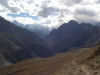
For a long time, Shimshal valley and its inhabitants had been isolated. The road has arrived for two years, making it easier to access these underrated trails. Difficult and long treks, on steep paths, they accumulate such altitude difference that your altimeter could lose the place.
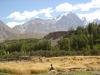
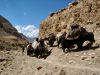
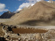
The way described here is the straightest up to Shimshal Pass summer pastures. Summer time is when you will be able to discover Shimshalis’ way of life as well as their wives’ who spend around 5 months at 4700 m, to take care of the cattle and prepare the famous yak cheese, qurut. The trails that will seem hard to you are their everyday life; for some of them who train to climb 8000 peaks, your 6 day trek is just a two day return trip, and they are loaded with weight, of course!
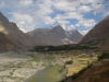
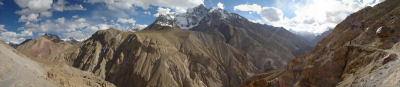
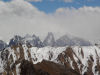
At Shimshal Pass, you will have an impressing view on unclimbed 6000 peaks, and the terra incognita surrounding them.
It is a popular destination for all the trekkers, and especially French people. Out of 50 persons who stayed in one of the two Shimshal village guesthouses this summer 2006, 23 of them were from the hexagon…that is to say, almost 50%!
Difficulty
From Gar to Sar à Arab Purien, the trail is jagged, it is really long and tiring. It is a trek for good walkers because of its distances and its relief, not to do if you have just arrived 3 days ago from abroad.
Organisation
Many possibilities when you arrive in Shimshal. Only ask the locals, they are whether guide, or porter or they know one. Moreover, during summer time, some have family at the pass; they won’t need persuading to come.
Be ready to pay around 1000 to 1200 rps per day for a guide, including food but no the tips (15 to 20 % of the total salary).
Porters ask 300 rps per stage, including food but not the tips (15 to 20 % of the total salary). There are 12 stages.
How to get there?
From Passu, ask there, everybody knows where and if the jeep of a special goes to Shimshal. Be patient, sometimes there is not during one or two days. It is true both ways, get some extra time.
A jeep must leave everyday around 1pam from Shimshal Guesthouse. From Passu Inn, go down towards Sost, after a turn and at the level of a big rock turn on your right, walk 50 m and enter a courtyard.
Period
From June to the end of September, the descent from the summer pastures is in two times, first around the 12th of September up to Shuveraz, and the second a month later up to Shimshal.
Resupplying
Passu, Aliabad. |
Itinerary
Day 1
Departure: 2850 m
Arrival: 3000 m
Distance: 13 km
Length: 4 to 6 hours
   |
Leave early from Shimshal village, going by the school, you will reach the main way. One kilometre later, you will cross « Michael Bridge », built thanks a Canadian’s donations. From there, don’t go up to Band E Sar, and follow the horizontal way. Walking on this type of terrain is easy but it’s not obvious to find your way. When you see Yazgil glacier appearing, you can as well start to see Gar E Sar in the distance, at the top of a regular slope in front of you. Aim for the gorge, far on the left, the crossing between the pebbles lasts a bit more than half an hour. |
Water: In Past Furzen, a brook comes from the mountain. In Wuch Furzeen, go back up the small valley, during 100 m the spring is obvious, it comes from a rift and runs on your right.
Day 2
Departure: 3350 m
Arrival: 4350 m
+ 1325 m, - 485
Distance: 20 km
Length: 8 to 10 hours
  |
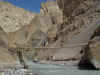
Leave early, follow the path crossing Wuch Furzeen. 300 m further, you can see the bridge below; the slope is very steep and requires some climbing down. Cross then suspension bridge, follow the river and go back up slowly, beware of the new passage particularly exposed. The trail narrows and overhangs a beautiful cliff. A bit further, a bend where starts the descent going directly to Purien e Ben. It is here that you will find the yak’s trail, those coming from Uween E Sar (4650) and Shachmirk (4550) passes. A bit higher, going back up the river, there would be hot springs. |
Water: there is a spring on the left bank, a bit above the houses.
Day 3
Departure: 4350 m
Arrival: 4650 m
+ 405 m, - 125 m
Distance: 8 km
Length: 2 to 3 hours
 |
Leaving Shuizherav, cross the bridge and ascend on the other side, 250 m of altitude difference. You will arrive in Abdullah Khan Maidun, grassy plains are huge and contrast with the landscapes seen the days before. It is advised to enter them in a good mood or singing. |
Water: A little bit above Shuwerth, a spring is well visible.
Day 4
Rest and visit around Shimshal Pass.
Day 5
Departure: 4650 m
Arrival: 3350 m
+ 540 m, - 1675
Distance: 28 km
Length: 8 to 10 hours
Take the same way back from Shuwerth up to Wuch Furzen. |
|
Day 6
Departure: 3350 m
Arrival: 3000 m
+ 765 m, - 1020
Distance: 15 km
Length: 6 à 8 hours
Take the same way back from Wuch Furzen up to Shimshal village. |
|
|
|
Extras
Mugaligh Sar
Departure: 4650 m
Arrival: 6050 m
+ 1400 m, - 1400
Distance: 8 km
Length: 6 to 8 hours
 |
To make the ascension easier, camp as close as possible to Mugalig Sar. Leave very early in the morning, count 4 hours 1 way. |
Water: Get it ready before the ascension.
Panorama on Braldu valley
Departure: 4650 m
Arrival: 5050 m
+ 600 m, - 600
Distance: 8 km
Length: 3 to 5 hours
  |
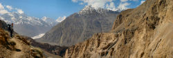
This peace of mountain located further down on the valley is inescapable; it will offer you an unforgettable panorama. |
Water: A creek on the way up.
ATTENTION Les treks qui sont décris dans cette rubrique ont tous été parcourus par l'auteur, les itinéraires y sont détaillés journalièrement, des cartes et photos les accompagnent. En aucun cas ces fiches, ne remplaceront l'expérience d'un guide local, elles sont un complément et doivent être prises comme tel ! Ne partez surtout pas seul, sans avertir qui que ce soit ! Le tracé de certains sentiers peut changer d'une année sur l'autre, les glissements de terrains, coulées de boue étant suffisamment nombreux. |