Route
Day 1
Departure: 2850 m
Arrival: 3000 m
Distance: 13 km
Length: 4 to 6 hours
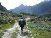 |
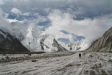
Thungol, is a departure base, follow the way that leads to Askhole, it is necessary to stop and register there at the check post. Then, continue to go up the valley in the middle of the fields, and at the bottom of scree slopes, the way is very weel marked. A few kilometers further, you cross the river coming from the Biafo Glacier, there is a fee for the bridge (As a rule, it is taken in charge by your guide). A great flat area ends up next to the Biafo, at Kophoron, in a willow oasis where tourism impact can be felt.
|
Day 2
Departure: 3000 m
Arrival: 3300 m
Distance: 16 km
Length: 5 to 8 hours
|
From Kophoron, the trail goes clearly up the valley. After having followed an affluent, and crossed a bridge, that is 1h30 walking, you reach Jula. Inescapable, the development of this site has set many grey cabins, showers toilets etc…useful but contrasting with the site. After an enjoyable break for eating, because the following part is long, take a path that comes back to the main valley, it goes up to the bottom, and then turns progressively on the left. One hour later and you can see Sham Tsok.
|
Day 3
Departure: 3300 m
Arrival: 3500 m
Distance: 7 km
Length: 2 to 4 hours
 |
This stage contrasts with that of the day before, from Sham Tsok, go up the valley during half an hour, than go above a gigantic landslide coming from an affluent on your left. Two ways are possible, one on top of this chaos, the other beneath, be careful to the river crossing, late in the day it could be dangerous.
A bit further, go up on the right along the mountain, the trails goes a bit down along the river, and goes up after to arrive in a woody area, you are in Paju. From this camp, the immensity starts to unveil and you can see some part of the Baltoro, the Cathedral, the Trango towers, etc…
|
Day 4
Day 5
Departure: 3500 m
Arrival: 4050 m
Distance: 17 km
Length: 6 to 9 hours
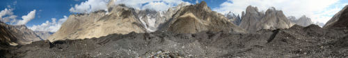
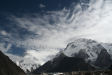
This long stage will bring you to the heart of the Baltoro. You leave Paiju on a well marked trail and after half an hour, you see the immensity of the glacier. Go up on the blocks, and cross on the right, you will notice the size of the river that comes out beneath.
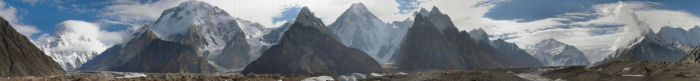
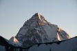
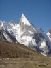
One hour crossing, close to a big block, you will see the famous Nameless Tower. Continue on this side, and little by little very vertical peaks unveil, Paiju Peak, Biaho, etc…Go over a sandy area, ideal for pictures, and after 1h30 walking, reach Khoburtse (3900m).Pleasant to stop and have a meal, this windy place is not as nice to sleep.
Go back on track for two hours more and reach Urdukas. Better located than the one before, this camp offers a wonderful panorama on most of the lower Baltoro peaks. Going further where the next stage starts, at the level of porters’ graves, you will have a view on Muztagh Tower and Broad Peak.
|
|
Day 6
Departure: 4050 m
Arrival: 4400 m
Distance: 12 km
Length: 5 to 7 hours
 |
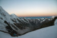
The trail takes immediately the glacier’s direction, where you end up after a short descent. The following part is punctuated by a few cairns. One hour later, Masherbrun unveils its splendor, and the peaks you have seen the day before almost seem ridiculous. The itinerary is only on the Baltoro up to Goro II. Be aware that starting from this camp, it becomes very cold; bring a good mattress to isolate yourself from the frozen ground.
|
Day 7
Departure: 4400 m
Arrival: 4650 m
Distance: 9 km
Length: 4 to 6 hours
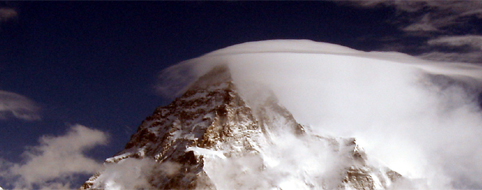
Go up along the glacier, one hour later, you have an exceptional panorama on the Muztagh tower that is on your left. Broad Peak and Gasherbrun IV appear at the bottom of the valley. At the junction between upper Baltoro and Godwin Austen Glacier is Concordia camp, the view is breathtaking. The impressing K2 pyramid overlooks the surrounding peaks at 360 °.
Day 8
Rest or day walk to Broad peak or K2 base camp.
RETURN: Take the reverse way, following the itinerary described above.
GONDOGORO LA
Day 9
Departure: 4400 m
Arrival: 4650 m
Distance: 9 km
Length: 4 to 6 hours
 |
From Concordia, a path punctuated of cairns goes up upper Baltoro. One hour later walking, you will see Vigne glacier, arriving from your right, take this direction. The large icy makes you gain altitude progressively until you arrive in a more broken up zone from where you get out and reach Ali camp.
|
Day 10
Departure: 5000 m
Arrival: 4850 m
Distance: 9 km
Length: 6 to 10 hours
|
You get up from 11pm for the first groups !
Go up 1 hour in blocks to reach a new camp that you might have reached the day before. A member of the rescue team will come with you during this ascension. Cross the glacier and walk up a slope getting steeper and steeper. Quickly, you will reach the ropes level, they are fixed up to the pass. According to the morphology of this place, changing year after year, you will certainly cross some crevasses covered with ladders.
Arriving at Gondogorola Pass, the landscape is incredible, in front of you, 4 peaks higher than 8000 m in a pocket handkerchief, behind a spectacular valley where Leila Peak thrones. If you reach the pass too early at night, you can wait below for the sunrise in the rescue team hut.
The descent is exhausting; 400 m of difference in height on ropes that are in a terrible shape…the following part is on scree slope, up to a glacier that you will cross. Starting from there, the slope is softer, the walk easier, 1h30 later you will reach Xhuspang.
|
Day 11
Departure: 4850 m
Arrival: 3300 m
Distance: 18 km
Length: 7 to 10 hours
 |
A long stage that goes gently down to Shaïcho. From Xhuspang, follow the trail which quickly crosses Gondogoro glacier, perpendicular to Leila Peak. The next part, quite easy, offers a great panorama on Masherbrun, and unveils at the bend of the path the gorgeous valley. To tone it down a bit, a river crossing after Golong. Don’t cross it too late, in the afternoon ice melting rises dramatically its water level.
After a few hours walking, you reach a cypress forest, laying its cards on the table for what comes next. Saïcho camp is nested at the bottom of the valley in a bosky bower, contrasting with the mineral world you are leaving.
|
Day 12
Departure: 3300 m
Arrival: 3000 m
Distance: 8 km
Length: 4 to 6 hours
 |
Take the trail that quickly crosses the river coming from K6 valley. The continuation is easy, descending on a soft slope, in the middle of woody areas. Close to Hushe, the area is cultivated and some inhabitants used to the tourists will not miss asking you some rupees or pens. From Hushe, the view on Masherbrun is awesome.
|
 |
|