Day 1
Shimshal – Shpoodeen
Departure: 3150 m
Arrival: 4430 m
-100 m + 1390 m
Distance: 15 km
Length: 8 to 10 hours
Get out of Shimshal, cross the river through Michael Bridge. Right after go back up on the side up to Band E Sar. Cross the river coming from Zargarben on the left. Ascend on the left bank along the creek. Enter the gorge; the trail crosses the creek a few times. The difference of altitude cumulates quickly, around 3600 m a scree slope; it is very steep and exposed to rock falling, be careful! At the end, a cattle gate, it is Tung E Sar, the relief flattens a bit in comparison with the scree slope. After 20 min, a new slope arriving straight in Zargarben. It is a break in the landscape, the valley is large, the bottom flat. On the right, Uween E Sar Pass (The Pass going high up) which allows you to reach Shimshal pass summer pastures, the yaks’ trail. If you are not acclimatized, this place is perfect to stop, count 1 or 2 days extra for the trek.
To go to Shpoodeen (rhubarb pass), continue ascending slowly, 500 m later, cross a creek coming from the right. 2km later, cross the main river and take a left on the other side, the path going up the scree slope. Still 20 min before going down, the panorama is superb and the valley magnificent. Go down to the river level and cross it; continue up to the angle, Shpoodeen huts are visible right after. 15 min remain before reaching the camp; Shpoodeen Pass is just above at 5400 m.
|
| |
Water : in the river coming from the pass, a bit unclear.
Day 2
Shpoodeen - Mandishalk
Shpoodeen - Mandishalk
Departure: 4430 m
Arrival: 4100 m
-925 m + 650 m
Distance: 15 km
Length: 7 to 9 hours
Shpoodeen – Boisum Pass
- 15 + 530
2 to 3 hours
Two ways starting from Shpodeen, on in the riverbed, the other one going along the scree slope; they meet a good km further. Go up the creek coming from the right, after one small hour, a green strech on the left; it is Jafervask (camp possible). The way is marked by cairns; it goes up during more than 1 hour up to a scree slope quite steep, 15 min later, Boisum Pass. The view on the other side is surprising, two beautiful lakes surrounded by mountains.
Cross this plain and go down up to a big cairn marking a break in the slope, it goes down! After one hour Perchowadesk (Where a young girl got tired), cross the river on the left and continue to go down, two other meadows follow between scree slopes, Pomerin and Kalbig Maidun. The trail is well marked; it goes down straight to Mandishalk, at the confluence with Ghuzerav River. Going back up the river, it is possible to come back to Shimshal going through Mai E Dur Pass, other passes are possible, be careful China is not far.
Water : A spring close to the river, very clear water.
|
| |
Day 3
Mandishalk - War E Ben
Departure: 4100 m
Arrival: 3900 m
-660 m + 370 m
Distance: 8 km
Length: 3 à 4 heures
Leave Mandishalk going down towards the river, after having walked along it less than 500m, go back up scree slopes on the left, the crossing of a glacier remains take 45 min before seeing Avduzi at the end of a small plain, it is some of Shimshal summer pastures. Continue walking up embankments and cross scree slopes during 30 min, another plain at the end with another stone stretch. There, it goes even higher, 3 hours after having left Mandishalk, the path is at 4000 m!
Just before the river cutting the scree slopes, the most obvious way is not the right one; go up well on the left during 300 m to cross it. After crossing the creek and before it is hemmed in by the gorge, go down to War E Ben below, after 25 min of a steep descent, pitch the tent in the plain close to the huts.
To not: On the way, you some original work of art made by a local from ibex horns.
Water : A spring close to the river.
|
Day 4
War E Ben – Chafchingol Base Camp
Departure: 3900 m
Arrival: 4300 m
-255 m + 710 m
Distance: 10 km
Length: 6 to 7 heures
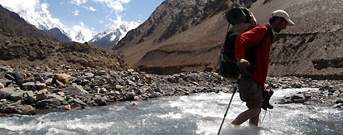
From War E Ben, walk up the valley during 500 m up to a cable crossing the Ghuzerav River. Cross the water course on a steel strand, and go back up on the other side, it is steep. Less than 5 min later, a spot possible for camping, take a right and go back down towards Chafchingol River, it is steep and a bit exposed. Walk up to bend blocking the way, it is where you have to cross the river. It is cold, very cold…There is some current and it is better to cross with other people holding each other, it is without mentioning the pebbles that come to hit you being pushed by the water. An unforgettable experience, Shimshalis would like to end with, they should set some cable to cross this water course in a close future. 300 m later, cross again the river, it is glacial, now you know it and it is hard to go again! Follow the water course during more than 1 km, up to a possible camping spot, if water level is too high, camp here and wait for the next day..
After this last crossing, it is over! Walk up the scree slope on the other side, up to a visible cairn form the distance. The following part alternates with jagging up to Targeen, a nice spring, somewhere to make fire and a pause to recover from your emotions. Fill your water tank at this level because it is possible that there is nothing in the camp. Continue less than one hour up to a water course running from the right, cross it. What comes next seems never to end until Chafchingol Base Camp. Two hours later, a small grassy stretch marked by cairns and huts at the bottom of Chafchingol.
Water : There is a spring crossing the camp, when we came in Mid-August 2007, i twas dry. Walk up 25 min along the river up to another spring.
Day 5
Chafchingol Base Camp- Koksil
Departure: 4300 m
Arrival: 3900 m
-1180 m + 970 m
Distance: 10 km
Length: 8 à 12 heures
Chafchingol Base Camp- Pass
- 0 + 925
3h30 - 4h30
Get up early. From the camp, climb a scree slope on the right; it leads straight to the first small valley. Follow it to the end, during 500 m altitude difference, around the end a drop of water where it is possible to fill your tank. Take a left, on scree slopes side, reach the ridges. Two options walk up the second small valley right beneath the pass or straight, along the ridge, 100 m before the pass, go sideways to reach it. The whole ascent is steep; the pass to be climbed by hands takes all its meaning. While you are going up, the landscape reveals itself; it is sublime, right in front of you, Sonia Peak 6350 m. The pass is marked by cairns and of them is huge. Go down on a soft slope during 500 m before getting on a perilous part. To reach the glacier base, two options.
The rocks’ way: cross two ice strips shifting forward on the left. No path, go right next to the precipice during about 50m up to the start of a chimney. Climb down to the base during about 20 metres, the following part is steep, reach the glacier base in 30 min, and watch for the rocks falls.
The glacier’s way: take some ropes and crampons, it is used when the first on is under snow. Don’t underestimate this way; it shouldn’t be done with too much snow: high avalanche risk...
At the confluence of these 2 glaciers, follow the thalweg during 500 m before moving forward on the left until rocks shelters. The next part is a pleasure, go down 2 hours per stage (hillside, flat stretch, hillside…) up to the end of the valley; the trail is well marked on the scree slope side. At the bottom of the trail, marmots whistling are animating the walk. Follow the river down to Koksil, many possibilities to camp. Just before Koksil Bridge, a nice green stretch.

|
|