This itinerary doesn’t take into account rest days; it is possible to take on in Baintha for acclimatization or after Hispar La.
Day 1
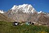
Askole – Namla
Departure : 3000 m
Arrival : 3350 m
-335 m + 675 m
Distance: 15 km
Length : 7 à 8 hours
 |
Get out Askole going up the valley. The track under construction is well marked, and walked by many groups going to Baltoro on the right. After 2 km, a climb up to the summit where you can see the valley and the terminal part of Biafo, go down et leave the Baltoro bridge on the right. Far on the left hand side, a small pass, this where you have to go.
After 1 hour, it is from this place you have the first view on the glacier, landslides hills surrounded by black ice. The trail follows the border of the lateral moraine ; before reaching a cliff, go down on the glacier, it’s steep. Continue along the Biafo’s limit one good hour until a camp where it is possible to eat. The trail continues until it is blocked by crevasses, 300 to 400 m before, get on the glacier and walk around the chaotic part. Continue 2 to 3 km, the way is not obvious, Namla is visible at the bottom of the first gully on the left. The surrounding area is hard; you have to zigzag to avoid crevasses. Get out of Biafo and ascend 30 m up to a grassy area crossed by a briny creek.
|
Water : It is better to stock up on the glacier, where you can.
Day 2
Namla – Mango
Departure : 3350 m
Arrival : 3650 m
-130 m + 430 m
Distance: 7 km
length : 5 à 6 hours
|
Descend, go on the left, and reach the glacier’s centre. Go up 2 to 3 h on a regular slope, this part is esthetical; there are many ice strips of different colours, some of an immaculate white, come from the upper part. On the left of numerous valleys, Mango is at the bottom of the biggest of these. Leave the ice tongue’s centre et go on the left.
A new crevassed area. At the bottom of the glacier, a torrent forms a small lake, cross it on the right and ascend up to a grassy area.
|
Water : on the glacier.
Day 3
Mango – Baintha
Departure : 3650 m
Arrival : 3900 m
-200 m + 420 m
Distance : 11 km
Length : 5 à 6 hours
|
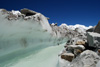
Go up on the side of the lateral moraine and go near a dried lake. Follow a pleasant part but without water. The trail continues 500 m before plunging on the glacier. Cross a chaotic part before reaching the centre. Ascend the glacier up to a flatter area. From now on, cross the central moraine and the numerous strips of different colours.
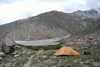
On the right hand side, a new glacier arrives, go above and after a broken zone, go up on lateral moraine on your right. A trail ascends steeply on the mountainside ; little by little a spectacular panorama on Biafo reveals itself. Pass by a construction and walk on a part of the trail a bit exposed, and descend on one of Baintha camps, marked by a big block.
Our guide assured us that it was Baintha 1… I would rather think it is another one located 1 hour later which he told us was Baintha 2. It remains perfect for camping.
|
Water : A river a few meters further… unclear water.
Day 4
Baintha – Nakpogoro ou glacier à la hauteur de Nakpogoro
Departure : 3900 m
Arrival : 4250 m
-135 m + 480 m
Distance: 12 km
Length : 7 à 8 hours
It is possible to camp on the glacier, at Baintha level, and this way you can avoid the camps on the side up to Kani Basa.
Ascend 1 hour along the lateral moraine, a few stages linked by small hills, up to Baintha 2. From there, go back on the glacier, cross the lateral moraine, the trail is marked by a cairn. Another chaotic part but short, thankfully, leads you to the glacier. The walk is easier than the previous days. Take over two glaciers coming from the right and continue to go up along unusual landscapes. The following part is full of crevasses, zigzag between the fractures; aim at a peak of more than 1000 m high shaped liked a water drop, Nakpogoro camp is just beneath. Cross a chaotic zone and step on the side of the glacier; the camp is marked by buildings, at the foot of a gigantic cliff.
Nakpogoro, Marpogoro, Karpogoro, three camps ending in pogoro, meaning rock. Nak means black, Mar red, and Kar white, Nakpogoro the black rock, etc ...
|
|
Water: The camp is crossed by a creek, unclear water.
Day 5
Nakpogoro – Karpogoro ou glacier à la hauteur de Karpogoro
Departure : 4250 m
Arrival : 4500 m
- 65 m + 220 m
Distance : 7 km
Length : 4 à 5 hours
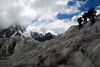 |
Come back straight on the glacier, the following zone is full of crevasses. Continue by reaching the lateral moraine. After 2 km, the relief gets flatter, come a little bit back on the right, pass crevassed camps. Continue on this soft slope leading to Karpogoro level ; whether you stay on the glacier, or you go to the camp, it becomes dangerous, the zone is much fractured.
|
Water : Glacier
Day 6
Karpogoro – Camp de base du Hispar La
Departure : 4500 m
Arrival : 4850 m
- 85 m + 420 m
Distance : 9 km
Length : 7 à 9 heures
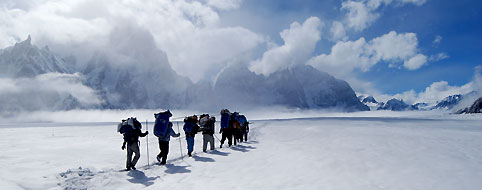
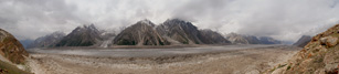
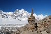
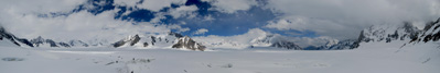
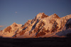
If you stopped in Karpogoro, go back on the glacier flat part, otherwise continue. Going up, on the left, a technical pass, Sokha La, this can lead you to Chogolungma valley. The closer you get to Snow Lake, the more unreal the landscape gets; this glacial bassin is the biggest in the world outside the polar areas, it measures 1500 m of ice deep.
The progression is punctuated by crevasses hidden beneath the snow carpet. All the crossing is done in rope teams. The pass is visible on the left, distances are not obvious, it seems close but you need a few hours walking to reach it. Go on your left and up to the camp on the mound, at the bottom of the pass. The view is breathtaking, unreal !
Water : Melt the snow.
Jour 7
Camp de base du Hispar La – Kani Basa
Departure : 4850 m
Arrival : 4700 m
- 690 m + 470 m
Distance : 15 km
Length : 9 à 12 hours
Camp de base du Hispar La – Col du Hispar La
Departure : 4850 m
Arrival : 5150 m
- 30 m + 300 m
Distance : 5 km
Length : 3 à 4 heures
|
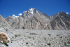
A long and hard day, leave early. Go up in the middle of the valley to avoid avalanches on the side. Zigzag between crevasses, after 2 hours, come out on the flat area, the progression is easier, the pass is 2 km further, marked by a change of slope, it goes gently down ! Continue 2 hours up to a slide, the view on Hispar valley is breathtaking, in the distance, Rush Phari peak is minuscule!
Descend in the middle of the valley, crossed by crevassed zones. Little by little, Sin glacier, coming from the right, unveils. After 1h30, go on your right, and reach Sin glacier. The progression is a pain at times; cross the glacier and go up about 50 metres up to Kani Basa Camp, marked by cairns.
|
Water : At the glacier
Day 8
Kani Basa - Hagure Shangal 2
Departure : 4600 m
Arrival : 4300 m
- 640 m + 305 m
Distance: 11 km
Length : 6 à 8 hours
|
We could almost say that the hardest part of the trek is over, but it’s not the case. All the rest of the way is jagged and 5 glaciers remain to cross !
Going down gently on the side of the glacier. Continue one good hour, on a jagged trail, until going up on the lateral moraine. The vegetation sets up until Hagure Shagal 1, a camp in the middle of a verdant oasis, 500 m further a magnificent spring coming from the right. After one hour, another glacier, easy to cross, go up on the other side going through landslides making it harder to walk. Another green area, ran across by streams, stop at the last one marked by building. Hagure Shangal 2, don’t overtake the river coming from a glacier on the right.
|
Water : A spring , and the river just after the camp.
Day 9
Hagure Shangal 2 - Shiqam Baris
Departure : 4300 m
Arrival : 4150 m
- 475 m + 315 m
Distance : 12 km
Length : 6 à 8 hours
 |
Get out of the camp, go by the river, the trails alternate between meadows and landslides up to Jutmo glacier, follows a descent very steep down to the glacier. The crossing offers spectacular views on the surrounding peaks. Count 2 to 3 hours from the entrance to the exit of the glacier. The exit is very steep, during 10-15 min up to the cairns ; they mark a more pleasant part.
Possible camps come one after the other, with clear water. After one good hill, we can catch a glimpse at the bottom of the valley at a ridge turn. Continue half an hour up to a very steep descent overlooking the valley dominated by another glacier. After the stream, the camp is more pleasant. Welcome to Shiqam Baris.
|
Water : A river next to the camp, unclear water.
Day 10
Shiqam Baris - Bitanmal
Departure : 4300 m
Arrival : 3950 m
- 530 m + 260 m
Distance : 12 km
Length : 4 à 6 hours
 |
Get out of Shiqam Baris, after 15 min, reach the moraine of a glacier coming from the right, cairns show the following part of the trail above. A very steep descent down to the glacier, the crossing is short but intense, watch out for stones falling. The following path is very exposed under hanging blocks. After 10 min, back to a more pleasant zone. Half an hour jagged walking up to the Red Star camp. Go up the glacier lateral moraine coming form the right, the descent is steep and very exposed.
Cross the strip of ice coming from Kunyang Chish, on the other side, it is some fun climbing ; we’ve been told yaks can go through. Our glacier exit the most exposed of the trek, it is narrow, exposed right above a drop! At the exit, continue half an hour up to Dachigan, nice views on the valley, clear water, large grassy zone, perfect camp. Continue one hour up to Bitanmal, another large grassy area, with an unimpeded outlook over the surrounding giants.
|
Water : A river at the camp.
Day 11
Bitanmal - Hispar
Departure : 3950 m
Arrival : 3350 m
- 990 m + 325 m
Distance : 13 km
Length : 5 à 6 hours
 |
Go up the glacier lateral moraine coming from Destagil Sar, go down and cross Kunyang glacier, after half an hour the trail going up appears on the other side, slightly on the right. The exit is perilous, at the foot of icy cliffs, run under the stones falling up to the trail !
Go back up, the trail is exposed. The following part is pleasant; eventually it goes down regularly up to Hispar, many possible camps on the way. Cross Hispar bridge, 40 rps per person (pay at the village). Walk back up 10 min. In the village, a camp: 150 rps per tent and 200 rps for the kitchen tent.
A road is under construction, it should allow people to go quickly to Hunza, get the information about jeeps and PRICES!! It is still possible to walk to Nagyr by what will soon be the old way.
|
Water : Ask the village
Days 11 & 12
Hispar - nagyr
Departure : 3350 m
Arrival : 2650 m
- 1300 m + 600 m
Distance : 30 km
Length : 10 à 13 hours possible in 1 day
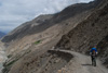 |
Leave Hispar village, descend on the unsealed road between wheat fields, cross the bridge. The next part goes beneath scree slopes, be careful. After 3 hours, another bridge, cross it to go back up to Horo. The road under construction continues straight up, ask before if it practicable. Horo is not a village but a farm with one building, somewhere to camp but don’t hope for more. It is possible to stop here for a night.
Continue on the road that goes up along the hillside, up to a flatter area, a bit more than a km further. Half an hour later, a view over Nagyr valley, the road descends at least ; only 2 hours to a bridge, cross it, and 300m after, take a left on the gorge. Go through a small desert valley, 1 km before another bridge leading to Nagyr. From there, it is an inhabited zone; the inhabitants came to offer us tons of apricots! The following part is never ending up to Nagyr Bazaar, 2 hours later. From there it is possible to take Jeeps for Aliabad and Karimabad or book a special for 700 rps.
|
Water : Springs all along the way. After Horo, not much up to Nagyr.

|