Day 1
Departure: 2850 m
Arrival: 3000 m
Distance: 13 km
Length: 4 to 6 hours
|
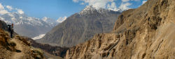
Leave early from Shimshal village, going by the school, you will reach the main way. One kilometre later, you will cross « Michael Bridge », built thanks a Canadian’s donations. From there, don’t go up to Band E Sar, and follow the horizontal way. Walking on this type of terrain is easy but it’s not obvious to find your way. When you see Yazgil glacier appearing, you can as well start to see Gar E Sar in the distance, at the top of a regular slope in front of you. Aim for the gorge, far on the left, the crossing between the pebbles lasts a bit more than half an hour.
When you arrive in front of the Shuiveraz river, you cannot go on unless you cross it by foot. It is useless, about 50 metres before, a trail ascends suddenly on your left, take it; it will bring you to the bridge. It’s there that the gorge opens up. Take the path going back up on the other side; be careful, it is very narrow and exposed at the top, mainly when you go down. After this first taste, the ascent softens.
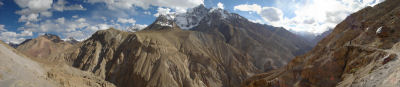
Slightly on your left, further than the first projecting ledge, a path on the slope side. It is the one you will have to take; ascending go slightly on you right, to avoid too steep zones. Go around the first projecting ledge through the right, and get back on the track going to Gar E Sar. Incredible views on the Hispar Muztagh.
A unique trail starts here, a Shimshali feat! Fringing with precipices, it is impressing and exhausting! It is jagged, ascending 50 m before going down and start again. 3 hours later walking like this, you can notice Past Furzeen below, the trail descends very steeply; on the way back, choose a path easier, well marked, leave on the right when you go back up.
From here you are one hour before Wuch Furzen; go back up behind Past Furzeen. After having flirted again with precipices, it goes along Chart Pirt hillside during 1 km and a half, and plunges again towards Wuch Furzen, 250 m below. The descent is extremely steep. On the way back, don’t take the same way: follow the small valley, go beyond the spring, and 100 m further take a right following the scree slope foot prints.
In Wuch furzeen, stay near the first hut to pitch your tent, it is closer to the spring.
|
Water: In Past Furzen, a brook comes from the mountain. In Wuch Furzeen, go back up the small valley, during 100 m the spring is obvious, it comes from a rift and runs on your right.
Day 2
Departure: 3350 m
Arrival: 4350 m
+ 1325 m, - 485
Distance: 20 km
Length: 8 to 10 hours
|
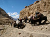
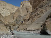
Leave early, follow the path crossing Wuch Furzeen. 300 m further, you can see the bridge below; the slope is very steep and requires some climbing down. Cross then suspension bridge, follow the river and go back up slowly, beware of the new passage particularly exposed. The trail narrows and overhangs a beautiful cliff. A bit further, a bend where starts the descent going directly to Purien e Ben. It is here that you will find the yak’s trail, those coming from Uween E Sar (4650) and Shachmirk (4550) passes. A bit higher, going back up the river, there would be hot springs.
From there it is possible to catch a glimpse at the first door, built 200 m above and which closes the way to yaks. Cross the stream and go back up on a very steep slope up to the gate. Take the picturesque path hold by juniper beams going straight up on your left.
Little by little, you can see the plateau starting right after the second door. From there, it gets easier. Continue straight up the main valley, 1 hour later you are in Arab Purien. Go back up, cross the very small valley of Qerqazi Kishk, and continue on the other side. After 2 km, the trail shifts and goes along the river once again. A bit further, cross the bridge, and continue towards the bottom of the valley, the way is long but well marked by cairns. After a few hours walking, you arrive in Shuizherav, the alternative to Shuwerth summer pastures, where women spend a month before going back to Shimshal village. Spots to pitch a tent are numerous.
|
Water: there is a spring on the left bank, a bit above the houses.
Day 3
Departure: 4350 m
Arrival: 4650 m
+ 405 m, - 125 m
Distance: 8 km
Length: 2 to 3 hours
 |
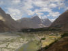
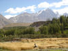
Leaving Shuizherav, cross the bridge and ascend on the other side, 250 m of altitude difference. You will arrive in Abdullah Khan Maidun, grassy plains are huge and contrast with the landscapes seen the days before. It is advised to enter them in a good mood or singing.
It is on a gentle slope that you go across this zone, the rainbow coloured peaks appear 1 by 1. A little bit further, you go along two lakes, where the surrounding summits are mirrored, avoiding walking your feet in the mud. You will see a hill in the distance blocking the horizon, it is Shimshal Pass. Cross it and go down towards Shuwerth, less than 1 km further, welcoming Shimshalis will show you camping areas.
|
Water: A little bit above Shuwerth, a spring is well visible.
Day 4
Rest and visit around Shimshal Pass.
Day 5
Departure: 4650 m
Arrival: 3350 m
+ 540 m, - 1675
Distance: 28 km
Length: 8 to 10 hours
Take the same way back from Shuwerth up to Wuch Furzen. |
|
Day 6
Departure: 3350 m
Arrival: 3000 m
+ 765 m, - 1020
Distance: 15 km
Length: 6 à 8 hours
Take the same way back from Wuch Furzen up to Shimshal village. |
|
 |
|